Paraguana peninsula of winds
Text and all photos by Rem Sapozhnikov (January 2007)
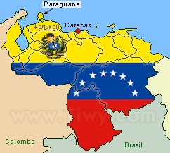
In Venezuela there is a beautiful peninsula with picturesque scenery, salty sea winds and endless golden beaches. It is Paraguana Peninsula. It is 500 km to the west from Caracas in the state of Falcon. The peninsula is 60 km from the north to the south and 54 km from the west to the east. From the north and east the peninsula is washed by the Caribbean Sea, at the south the sandy beaches of Paraguana face the Coro Bay, and in the west the Venezuela Bay.
Once the peninsula used to be an ordinary island just like Curacao, Aruba or Bonaire. Nowadays the former island is joined with the continent by flat and straight 25 km long and about 4 km wide neck of land. The western part of the neck is a continuous beach, in the eastern part there are a lot of sandbanks and salines.
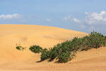
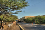
Introduction to Paraguana begins with the national park Los Medanos, which is a drifting dunes park. Some of them are 30 meters high. To climb the dune, listen to its sandy ring, burn your soles by scorching sands, and then slide down as if from the snow hill with cheers, - these are unforgettable impressions of Los Medanos.
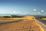
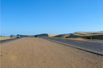
The dunes wage an attack at the peninsula. Especially suffers the road that runs from Coro to Punto Fijo. Quite recently they have built in 2 new paved lanes in each direction. And right in time! Near the road, among the sands one can see parts of old highway that was practically completely devoured by dunes. Certain still visible portions of the road reminded me of my first trip to the peninsula in mid 80s of the last century.
Soon the dunes will finally «digest» the old road and get down to the new one. The attack has already begun. People try to stop this movement by means of heavy machinery. Who will win man or nature?
You can see dunes in other parts of the peninsula. Pictures taken at the sands of Paraguana can easily pass for the pictures from Sahara desert.
|
|
 |
|
 |
|
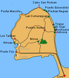
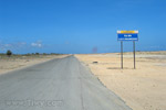
from Coro to
| Adicora | 65 Km |
| Buchuaco | 67 Km |
| Supi | 73 Km |
| Pueblo Nuevo | 78 Km |
| Punto Fijo | 84 Km |
| Cabo San Roman | 98 Km |
|
|
 |
|
 |
|
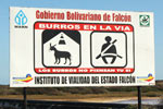
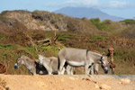
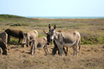
Right after the dunes with regular permanency you come across rather an interesting traffic sign with quite a disputable message: «Donkeys on the road. Donkeys don't think, but you do». And really herds of onagers wander around the peninsula and make an integral part of its scenery.
|
|
 |
| |
 |
|
 |
|
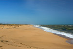
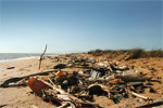
Total length of the sea shore is 300 km. Kilometers of luxurious beaches! In tourist zones the beaches are periodically cleaned, and at the natural beaches, at the eastern shore, a continuous band of various rubbish is stretching on the sand along the sea. The waves returned it back to people, as if blaming: hey, you, humanoids! The wind scatters the rubbish over the expanses of the peninsula, putting shredded plastic bags on cactuses. It is here that you start to understand the anxiety of ecologists!
|
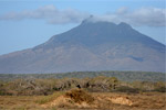
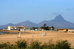
The only high point of the peninsula is Santa Ana mountain, the height of which comes to 830 m. In 1972 Santa Ana was declared a natural monument. From the mountain top in good weather you can see the isle of Aruba and other neighbouring islands.
The mountain top consists of three peaks: Buena Vista, Santa Ana and Moruy. Two roads lead to them: to the highest peak Moruy and to the central top Santa Ana. Although the access to the mountain is limited in the name of conservation of nature. As a whole, this is the correct decision, as the peninsula unpleasantly surprises you by a big amount of rubbish, even in the deserted places. And there is something to protect on the mountain: climbing 300 meters to the slopes of Santa Ana you can see the plants that grow only at 1000 meters and higher in other parts of Venezuela!
|
|
|
| |
|
History of discovery
Paraguana Peninsula was discovered on August 9, 1499 by navigator Alonso de Ojeda at dia de San Roman. It explains the name of the peninsula as Provincia de San Roman, that was used in all the documents of Spanish colonialists and maps of the world of that time.
|
|
| Information |
|
Alonso de Ojeda, (1468-1515), Spanish navigator, governor and conquistador. Sailed along the borders of Guayana, Venezuela, Trinidad and Tobago, Curacao, Aruba and Colombia (from the side of the Caribbean Sea). He is famous for giving the name of Venezuela («Little Venice») to the land that he explored during his first two travels. Discovered lake Maracaibo.
|
|
|
|
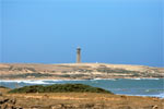
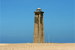
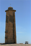
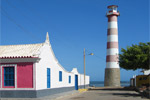
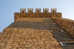
At present San Roman is the name of the cape that is at the extreme north of the peninsula and all continental Venezuela. On 30 November 1928 a beacon was opened at the cape. It used to be a bulky steel structure that got damaged by rust, which is especially active in this area due to high concentration of nitre.
By pains of commercial shipping, Sistema de Senalizacion Maritima de Venezuela (System of Venezuela Maritime Signalisation) and with fraternal help of the Chinese government a new beacon of cement and stone was built at the cape in February 2004. A powerful lamp, which is seen from the distance of 25 miles (45 km) is fitted at the top of 80 m high tower. The energy for such powerful light is obtained from the solar energy by means of solar batteries of 40 W each. The prototype for the shape of San Roman beacon was the most ancient in the world beacon made of stone, which is located in La Coruña, Spain.
|
 |
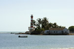
On the immense expands of Internet there are quite many photo-reports of travels along the peninsula with the obligatory «visit» of San Roman cape. And it is quite clear. People who get to that remote and deserted side of the peninsula feel as if they are travellers-discoverers. It was exactly as I felt.
In good weather from the cape on the horizon you can see the isle of Aruba, the distance to which is 31 km. In clear nights the lights of this isle are invitingly flickering on the horizon. It is famous for its comfortable beaches and gambling business.
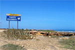
That is why, if you turned out to be at Paraguana, make sure to get to San Roman beacon! After Piedras Negras go along the dirt road to Puerto Escondido, from where you will see the cape.
 |
|
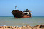 |
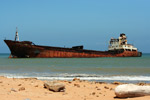
On your way to the beacon you will definitely see the stranded and rather rusty ship called "Denisse Marie". Her captain might have failed to see the beacon. Or he had too much of Venezuelan rum «Santa Teresa», or the storm was of unusual strength, similar to those that periodically rage at the area of Bermuda triangle. The silent skeleton of the ship radiates mystery. In the chart house in the shadow of running clouds the silhouettes of pirates of the XXth century seem to appear...
All this adds an unusual colour to the trip.
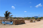
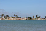
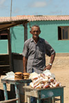
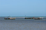
Puerto Escondido, similar to other villages of the peninsula, has its own beach and famous small sea-shore restaurant, where you can try fresh lobsters at quite a reasonable price.
Las Cumaraguas
 |
|
 |
|
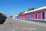
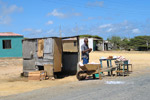
The town of Las Cumaraguas is situated at the north-west of the peninsula on the way to San Roman cape.
|
| In the roadside kiosk you can buy local souvenirs and «delicacies». Victor Jose Alvarez, owner of the kiosk, and from whom I got several pretty shells, turned out to be a pleasant person to talk to. His character is a reflection of kindness and hospitality of «semi-islanders». How about a «photo lest we should forget»? |
|
 |
|
 |
 |
|
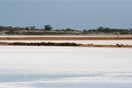
In Paraguana there are a lot of salines. Near to Las Cumaraguas a big saline land is sinking in heat. During the day at different position of the Sun salines change colour and glitter pink or bluish sparks.
|
 |
|
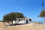
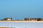
At the very sea shoreline there are ruins of once luxurious hotel «Club Hotel Medano Caribe», where petroleum tycoons and their family members liked to rest. But then they have disappeared. Night clubs and casinos of Aruba turned out to be more attractive. The Bolivarian government does not spare efforts for development of tourism. In the state of Falcon they plan to erect 20 new hotel points, where tourists could have a comfortable rest. «Medano Caribe» hotel will also be revived.
|
Economy and ecology.
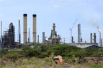
Amuay and Cardon the two largest in Latin America refineries, are situated in the south-east part of the peninsula. Both the plants, which are 15 km away one from another, are sometimes referred to as one «uniting» name - Paraguana refinery. Petroleum from the wells in the state of Zulia comes here through a 230 km long pipeline. Amuay and Cardon are the main economic basis of the state of Falcon. The refinery facility of the plants is estimated as from 800 thousand to a million barrels of petroleum a day! Fuel from these plants is both exported and used at the local market of the country.
 |
|
 |
Naturally, the «breath» of such an industrial giant is negatively reflected on the ecology. That is why, should I be given a choice, I would choose the towns in the north and east of the peninsula to swim and to have fresh fish.
Like in many other regions of Venezuela, the residents of Paraguana keep goats and from their milk the make butter and cheese. However, it is Paraguana that is most famous for its sweets made of goats' milk!
The peninsula attracts lovers of «shopping» by a «free trade zone» at Punto Fijo. Domestic appliances, alcohol, linen, clothes and shoes are duty free there. Special benefits are granted to hotels and food spheres. It is needless to say that such a «zone» is another and rather a weighty support for local tourist business.
...
 |
|
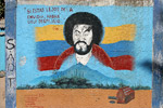
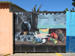
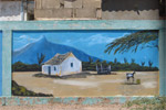
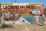
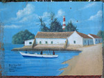
On the Latin American continent, the so called «murals» - a famous genre of walls painting is very popular. In big and small cities it is very common to see decorated stone fences and blind walls of the houses. And, as a rule, it is just a pleasure to examine this anonymous folk art. Here in Paraguana, in these murals there is a quintessence of all that you managed to see during that unforgettable trip.
I would like to preserve for history the name of one of such regional artists. At Paraguana many murals were bearing the name of Wilmer Yajure.
|
|
|
Adicora and El Supi
Beaches of Paraguana as almost all other in Venezuela do not have wave-breakers and therefore they are very attractive for windsurfers and kitesurfers as well as yachters. Adicora is the most attractive place in this respect. Windsurfer fans from all over the world come there. And in case you have never tried to give yourself to the elements of waves, in Adicora there are instructors that, for a modest payment, will teach you the aerobatics.
The beach of El Supi is shallow, protected by reefs from high waves. Here one can rest with little children and girl-friends, who cannot swim. In the holiday season the beaches are packed, but in off-season the towns are deserted and on many of them you can see melancholy ads «to let».
Weather.
Paraguana Peninsula is one of the driest places in Venezuela. It belongs to the dry regions with annual precipitations of 340.2 mm. But strong winds of up to 35 km/hr blow in Paraguana.
Most of the rainfall comes in the last months of the year. November, with its 83.5 mm of rainfall, is the record-breaker.
Average temperature is 27-28 degrees Centigrade. At the south-west from the mount Santa Ana the humidity rises due to trade winds.
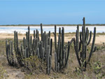
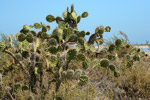
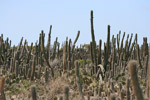
Flora.
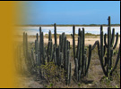
The flora of Paraguana Peninsula is scanty. Mainly vegetation that is resistant to draughts grow there. In the vicinity of Santa Ana there grow rock lilies, orchids, fig-trees.
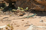
Fauna.
Major representatives of the peninsula fauna are onagers and goats, small lizards, scorpions (I didn't see the latter there). Unlike the land creatures, in the waters surrounding the peninsula, there live a lot of different sea creatures.
 |
Birds.
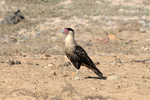
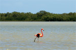
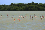
Many different birds, including bright and multicolored, are mentioned in the guide-books on the peninsula. Besides pelicans and sea gulls I managed to watch only flamingoes and the bird that I later identified as caracara.
|
Boca de Caño lake
The main attraction of Boca de Caño lake that can be seen from the road to El Supi, is flamingoes, which are scattered on the water mirror-like surface like note signs.
|
|
 |
|
 |
Text and all photos by Rem Sapozhnikov
|